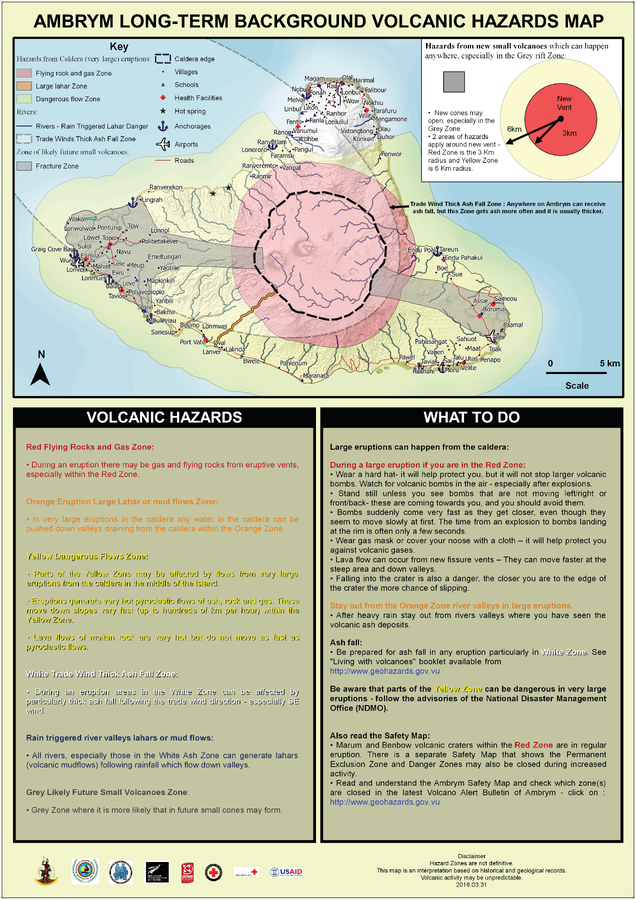
Ambrym Long-Term Background Volcanic Hazards Map
Ambrym, Vanuatu, 2016
Vanuatu Meteorology & Geo-Hazards Department. (2016). Ambrym Long-Term Background Volcanic Hazards Map. Government of Vanuatu, Vanuatu Meteorology & Geo-Hazards Department, Vanuatu National Disaster Risk Management Office, New Zealand Foreign Affairs & Trade Aid Programme, GNS Science, The Vanuatu Red Cross Society, Croix Rouge Francaise, USAID.
This map was produced by an official agency, but may not be the most recent, most complete, or main operational map.
For the current operational hazard map, please consult the proper institutional authorities.

Click on image for full-size map. If link seems broken, try the archived version.
Vanuatu Geohazards Observatory. (2016). Ambrym Long-Term Background Volcanic Hazards Map. Vanuatu Meteorology & Geo-Hazards Department, Vanuatu National Disaster Management Office, New Zealand Foreign Affairs & Trade Aid Programme, GNS Science, The Vanuatu Red Cross Society, Croix Rouge Francaise, USAID.Map Set
https://www.vmgd.gov.vu/vmgd/index.php/geohazards/volcano/volcano-info/resources
Other Maps In Set:
Map Data
Map ID 1159 Hazard Process(es) Ballistics; Gas; Lahars; Lava flows; PDCs; Tephra fall; Vent-opening hazards Hazard Zone Presentation Grouped by process (e.g. flowage/fall hazards) on a main map and series of insets Temporal Scale Background, or long-term, map Spatial Scale Island Publication Format Map sheet or poster Zonation Method(s) Geologic history Zonation Model(s) Scenario(s) Considered Hypothetical location; Size, VEI, or intensity; Style or type; Worst-case Hazard Zone Label(s) Hazard process name; Qualitative relative probability (e.g. high-medium-low) Probability Definition(s) Qualitative relative probability (e.g. high-medium-low); Scenarios imply probability Purpose Multiple: intended for multiple purposes including general hazard awareness, planning, and crisis management Audience General public and/or media Language(s) English Basemap(s) Hillshade Basemap overlay(s) Street map Diemsionality Planimetric (2D or map) view Color Scheme Red to Yellow
