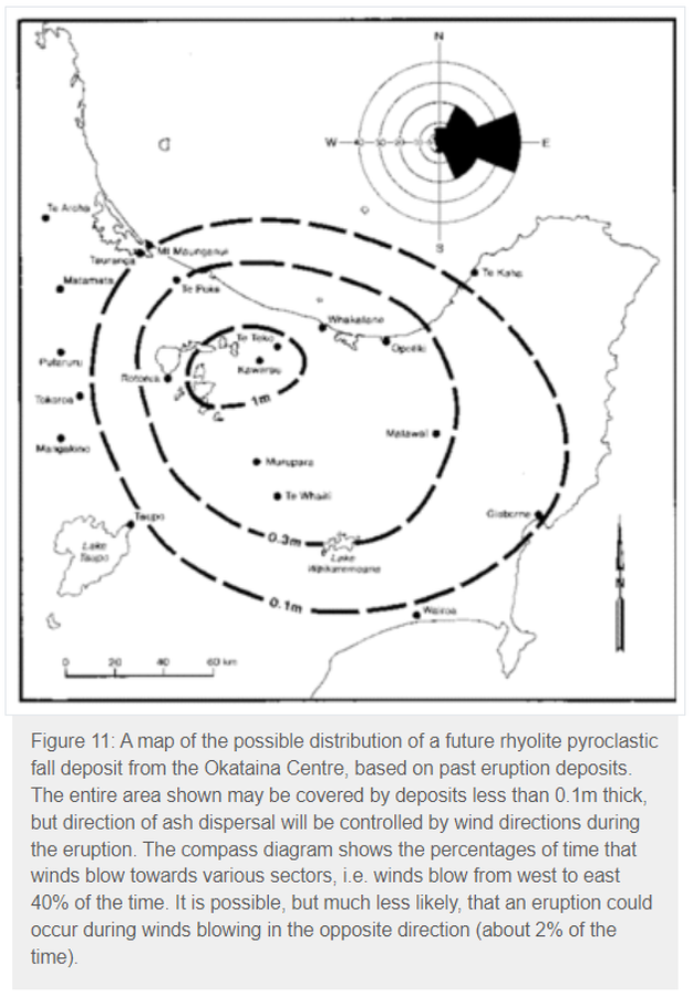
A map of the possible distribution of a future rhyolite pyroclastic fall deposit from the Okataina Centre, based on past eruption deposits
Okataina, New Zealand, 1993
Figure 11 in: Nairn, I.A. (1993). Volcanic hazards at Okataina Centre. 3rd ed. Ministry of Civil Defence, Palmerston North, NZ. Volcanic hazards information series 2. 29 p. Reproduced on website: https://www.gns.cri.nz/Home/Learning/Science-Topics/Volcanoes/New-Zealand-Volcanoes/Volcano-Geology-and-Hazards/Okataina-Volcanic-Centre-Geology
This map was produced by an official agency, but is NOT the most recent, most complete, or main operational map.
For the current operational hazard map, please consult the proper institutional authorities.

Click on image for full-size map. If link seems broken, try the archived version.
Nairn, I.A. (1993). Volcanic hazards at Okataina Centre. 3rd ed. Ministry of Civil Defence, Palmerston North, NZ. Volcanic hazards information series 2. 29 p. Reproduced on website: https://www.gns.cri.nz/Home/Learning/Science-Topics/Volcanoes/New-Zealand-Volcanoes/Volcano-Geology-and-Hazards/Okataina-Volcanic-Centre-GeologyMap Set
https://www.gns.cri.nz/Home/Learning/Science-Topics/Volcanoes/New-Zealand-Volcanoes/Volcano-Geology-and-Hazards/Okataina-Volcanic-Centre-Geology
Other Maps In Set:
Map Data
Map ID 3841 Hazard Process(es) Tephra fall Hazard Zone Presentation Single hazard: A single hazard process is represented on a main map panel Temporal Scale Background, or long-term, map Spatial Scale Volcano and surrounding area Publication Format Figure in a hazard assessment or mitigation plan Zonation Method(s) Geologic history Zonation Model(s) Scenario(s) Considered Composition; Season or weather; Specific past eruption Hazard Zone Label(s) Estimated value or Hazard Impact Metric Probability Definition(s) No probability definition was discernable from the map Purpose Land-use planning: Intended to inform citing of facilities, building restrictions, resource management, and infrastructure development Audience Multiple audiences (usually the public, civil authorities, and land-use planners) Language(s) English Basemap(s) Simple or sketch map Basemap overlay(s) Diemsionality Planimetric (2D or map) view Color Scheme Symbols and/or lines only
