
Taal Volcano Ballistic Projectiles Hazard Map
Taal, Philippines, 1999
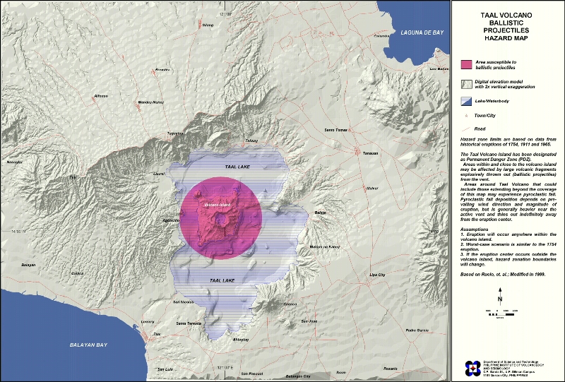
Philippine Institute of Volcanology and Seismology (PHIVOLCS). (2011). Taal Volcano Ballistic Projectiles Hazard Map. Quezon City.
This map was produced by an official agency, but is NOT the most recent, most complete, or main operational map.
For the current operational hazard map, please consult the proper institutional authorities.
Click on thumbnail for full-size map. We do not have copyright permission to display the full-size image. If you are the copyright holder and wish to provide copyright, please contact us at admin@volcanichazardmaps.org. If link seems broken, try the archived version.
Map Set
Philippine Institute of Volcanology and Seismology (PHIVOLCS). (1999). Taal Volcano Hazard Maps.
Other Maps In Set:
Map Data
| Map ID | 3486 |
|---|---|
| Hazard Process(es) | Ballistics; Tephra fall |
| Hazard Zone Presentation | Single hazard: A single hazard process is represented on a main map panel |
| Temporal Scale | Background, or long-term, map |
| Spatial Scale | Volcano and surrounding area |
| Publication Format | Map sheet or poster |
| Zonation Method(s) | Geologic history |
| Zonation Model(s) | |
| Scenario(s) Considered | Specific past eruption; Worst-case |
| Hazard Zone Label(s) | Hazard process name |
| Probability Definition(s) | No probability definition was discernable from the map |
| Purpose | Multiple: intended for multiple purposes including general hazard awareness, planning, and crisis management |
| Audience | Multiple audiences (usually the public, civil authorities, and land-use planners) |
| Language(s) | English |
| Basemap(s) | Hillshade |
| Basemap overlay(s) | Street map |
| Diemsionality | Planimetric (2D or map) view |
| Color Scheme | Single color |