
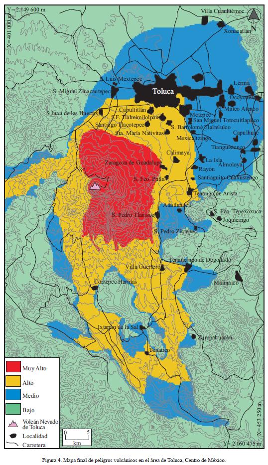
Mapa final de peligros volcánicos en el área de Toluca, Centro de México
Final map of volcanic hazards in the Toluca area, Central Mexico
Nevado de Toluca, Mexico, 2006
Figure 4 in: Aceves-Quesada, F., López-Blanco, J., & Martin del Pozzo, A. L. (2006). Determinación de peligros volcánicos aplicando técnicas de evaluación multicriterio y SIG en el área del Nevado de Toluca, centro de México. Revista Mexicana de Ciencias Geológicas, 23(2), 113-124.
This hazard map is the result of scientific research and was published in academic literature.
It is presented here to serve as an example of the map type or the map-making methodology. It is NOT the official, operational map. For the current operational hazard map, please consult the proper institutional authorities.
Click on thumbnail for full-size map. We do not have copyright permission to display the full-size image. If you are the copyright holder and wish to provide copyright, please contact us at admin@volcanichazardmaps.org. If link seems broken, try the archived version.
Aceves-Quesada, F., López-Blanco, J., & Martin del Pozzo, A. L. (2006). Determinación de peligros volcánicos aplicando técnicas de evaluación multicriterio y SIG en el área del Nevado de Toluca, centro de México. Revista Mexicana de Ciencias Geológicas, 23(2), 113-124.Map Set
http://www.scielo.org.mx/scielo.php?pid=S1026-87742006000200001&script=sci_arttext
Other Maps In Set:
Map Data
Map ID 3394 Hazard Process(es) Debris avalanches; Lahars; PDCs; Tephra fall Hazard Zone Presentation Hazard level-focused: All or most hazards are combined by hazard level on a main map panel Temporal Scale Background, or long-term, map Spatial Scale Volcano and surrounding area Publication Format Figure in a journal article Zonation Method(s) Derived/simplified from another map Zonation Model(s) Scenario(s) Considered Season or weather; Specific past eruption; Style or type Hazard Zone Label(s) Qualitative relative probability (e.g. high-medium-low) Probability Definition(s) Qualitative relative probability (e.g. high-medium-low) Purpose Scientific interest: Intended for scientific research and general scientific interest; usually published in academic journals Audience Scientists (usually in scientific publication) Language(s) Spanish Basemap(s) Contour lines Basemap overlay(s) Street map Diemsionality Planimetric (2D or map) view Color Scheme Red to Green