
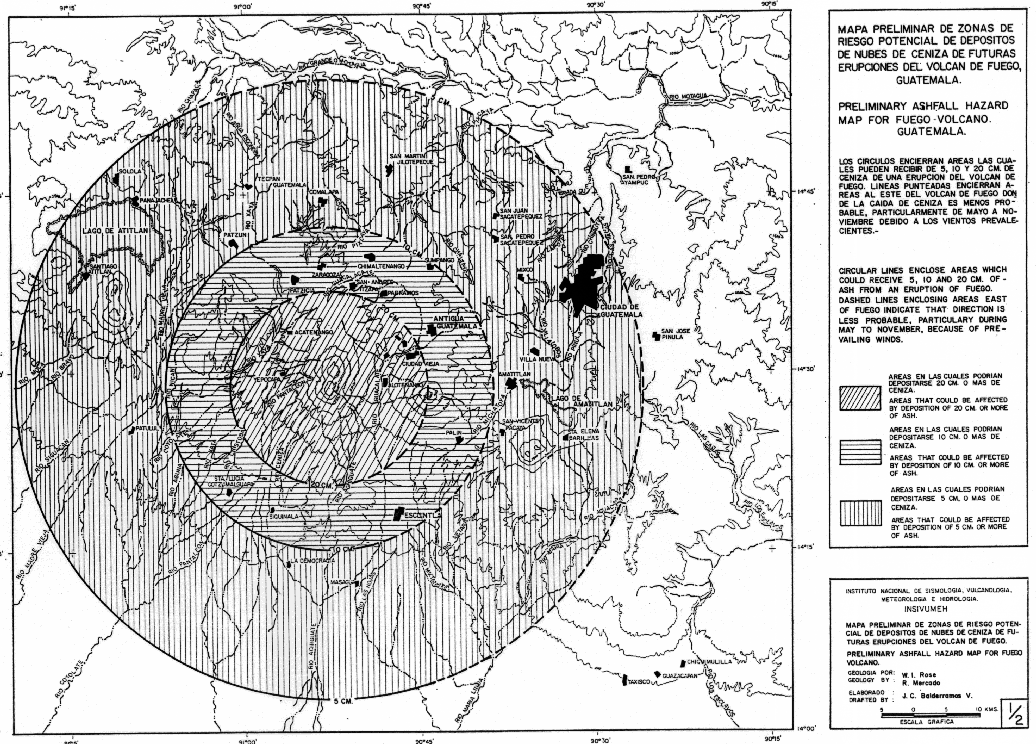
Mapa Preliminar de Zonas de Riesgo Potencial de Depositos de Nubes de Ceniza de Futuras Erupciones del Volcan de Fuego, Guatemala - Preliminary Ashfall Hazard Map for Fuego Volcano, Guatemala
Preliminary Map of Zones of Potential Risk of Deposits of Ash Clouds from Future Eruptions of the Fuego Volcano, Guatemala - Preliminary Ashfall Hazard Map for Fuego Volcano, Guatemala
Fuego, Guatemala, 1988
Map 1 in: Mercado, R. & Rose, W.I., 1988. Mapa preliminar de zonas de riesgo potencial de depositos de nubes de ceniza de futuras erupciones del volcan de Fuego, Guatemala - Preliminary ashfall hazard map for Fuego volcano Guatemala. Instituto Nacional de Sismología, Vulcanología, Meteorología e Hidrología (INSIVUMEH), Ciudad de Guatemala.
This map was produced by an official agency, but is NOT the most recent, most complete, or main operational map.
For the current operational hazard map, please consult the proper institutional authorities.
Click on image for full-size map. If link seems broken, try the archived version.
Map Set
Map Data
Map ID 3862 Hazard Process(es) Tephra fall Hazard Zone Presentation Single hazard: A single hazard process is represented on a main map panel Temporal Scale Background, or long-term, map Spatial Scale Volcano and surrounding area Publication Format Unknown format Zonation Method(s) Geologic history Zonation Model(s) Scenario(s) Considered Season or weather Hazard Zone Label(s) Estimated value or Hazard Impact Metric Probability Definition(s) No probability definition was discernable from the map Purpose Multiple: intended for multiple purposes including general hazard awareness, planning, and crisis management Audience Multiple audiences (usually the public, civil authorities, and land-use planners) Language(s) English; Spanish Basemap(s) Contour lines Basemap overlay(s) Diemsionality Planimetric (2D or map) view Color Scheme Symbols and/or lines only