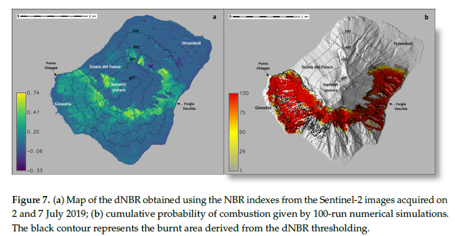
(a) Map of the dNBR obtained using the NBR indexes from the Sentinel-2 images acquired on 2 and 7 July 2019; (b) cumulative probability of combustion given by 100-run numerical simulations
Stromboli, Italy, 2024
Figure 7 in: Guardo, R., Bilotta, G., Ganci, G., Zuccarello, F., Andronico, D., & Cappello, A. (2024). Modeling Fire Hazards Induced by Volcanic Eruptions: The Case of Stromboli (Italy). Fire, 7(3), 70.
This map was produced by an official agency, but may not be the most recent, most complete, or main operational map.
For the current operational hazard map, please consult the proper institutional authorities.

Click on image for full-size map.
Map Set
Guardo, R., Bilotta, G., Ganci, G., Zuccarello, F., Andronico, D., & Cappello, A. (2024). Modeling Fire Hazards Induced by Volcanic Eruptions: The Case of Stromboli (Italy). Fire, 7(3), 70.
https://doi.org/10.3390/fire7030070
Other Maps In Set:
Map Data
Map ID 4187 Hazard Process(es) Fire Hazard Zone Presentation Single hazard: A single hazard process is represented on a main map panel Temporal Scale Background, or long-term, map Spatial Scale Island Publication Format Figure in a journal article Zonation Method(s) Probabilistic modeling Zonation Model(s) VolcFire (Guardo et al. 2024) Scenario(s) Considered Season or weather; Source location or direction Hazard Zone Label(s) Numeric probability Probability Definition(s) Numeric probability Purpose Scientific interest: Intended for scientific research and general scientific interest; usually published in academic journals Audience Scientists (usually in scientific publication) Language(s) English Basemap(s) Hillshade Basemap overlay(s) Contour lines Diemsionality Planimetric (2D or map) view Color Scheme Red to Yellow
